


Our Company also serves as a Real Estate Advisor Real to provide real estate services in the twin cities of CDA Islamabad and RDA Rawalpindi. Since Founded to Till Now as the oldest service of the Group our team works in the Sale and Purchase of Residential and Commercial Properties for our honorable Clients
We Deal In


Residential Properties
Commercial Properties
Islamabad History
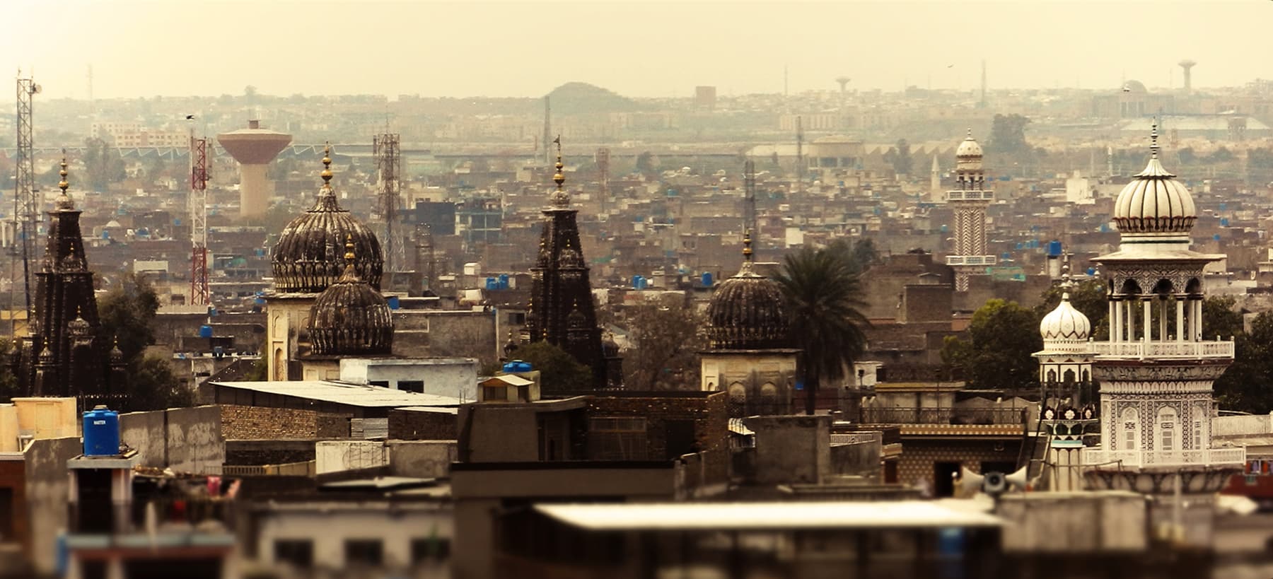
The capital city of Pakistan, Islamabad is located in the northwest of the country on Potohar Plateau. This area has been significant in history for being a part of the crossroads of the Rawalpindi and the North West Frontier Province. The city was built in 1960 to replace Karachi as the Pakistani capital, which it has been since 1963. Due to Islamabad's proximity to Rawalpindi, they are considered sister cities.
Compared to other cities of the country, Islamabad is a clean, spacious and quiet city with lots of greeneries. The site of the city has a history going back to the earliest human habitations in Asia. This area has seen the first settlement of Aryans from Central Asia, ancient caravans passing from Central Asia, and the massive armies of Tamerlane and Alexander.
To the north of the city you will find the Margalla Hills. Hot summers, monsoon rains and cold winters with sparse snowfall in the hills almost summarize the climate of this area. Islamabad also has a rich wildlife ranging from wild boars to leopards.
After the formation of Pakistan in 1947, it was felt that a new and permanent Capital City had to be built to reflect the diversity of the Pakistani nation. It was considered pertinent to locate the new capital where it could be isolated from the business and commercial activity of the Karachi, and yet is easily accessible from the remotest corner of the country.
A commission was accordingly set in motion in 1958, entrusted with the task of selecting a suitable site for the new capital with a particular emphasis on location, climate, logistics and defense requirements, aesthetics, and scenic and natural beauty.
After extensive research, feasibility studies and a thorough review of various sites, the commission recommended the area North East of the historic garrison city of Rawalpindi. After the final decision of the National Cabinet, it was put into practice. A Greek firm, Doxiadis Associates devised a master plan based on a grid system, with its north facing the Margallah Hills. The long-term plan was that Islamabad would eventually encompass Rawalpindi entirely, stretching to the West of the historic Grand Trunk road.
Islamabad nestles against the backdrop of the Margallah Hills at the northern end of Potohar Plateau. Its climate is healthy, pollution free, plentiful in water resources and lush green. It is a modern and carefully planned city with wide roads and avenues, elegant public buildings and well-organized bazaars, markets, and shopping centers.
The city is divided into eight basic zones: Administrative, diplomatic enclave, residential areas, educational sectors, industrial sectors, commercial areas, and rural and green areas.
The metropolis of Islamabad today is the pulsating beat of Pakistan, resonating with the energy and strength of a growing, developing nation. It is a city, which symbolizes the hopes and dreams of a young and dynamic nation and espouses the values and codes of the generation that has brought it thus far. It is a city that welcomes and promotes modern ides, but at the same time recognizes and cherishes its traditional values and rich history.


Rawalpindi History
Rawalpindi راولپݨڈى, commonly known as Pindi پݨڈى,, is a city and capital of Rawalpindi Division located in the Punjab province of Pakistan. Rawalpindi is the fourth-largest city proper in Pakistan, while the larger Islamabad-Rawalpindi metropolitan area is also the country’s fourth-largest metropolitan area. Rawalpindi is adjacent to Pakistan’s capital of Islamabad, and the two are jointly known as the “twin cities” on account of strong social and economic links between the cities.
Rawalpindi is located on the Pothohar Plateau, known for its ancient Buddhist heritage, especially in the neighboring town of Taxila – a UNESCO World Heritage Site. The city was destroyed during the invasion of Mahmud of Ghazni before being taken over by Gakhars in 1493. In 1765, the ruling Gakhars were defeated as the city came under Sikh rule, and eventually became a major city within the Sikh Empire based in Lahore. The city was conquered by the British Raj in 1849, and in 1851 became the largest garrison town of the British Indian Army. Following the partition of British India in 1947, the city became home to the headquarters of Pakistan Army hence retaining its status as a major military city.
Construction of Pakistan’s new purpose-built national capital city of Islamabad in 1961 led to greater investment in the city, as well as a brief stint as the country’s capital immediately before completion of Islamabad. Modern Rawalpindi is socially and economically intertwined with Islamabad, and the greater metropolitan area. The city is also home to numerous suburban housing developments that serve as bedroom-communities for workers in Islamabad. As home to GHQ of Pakistan Army & Benazir Bhutto International Airport, and with connections to the M-1 and M-2 motorways, Rawalpindi is a major logistics and transportation centre for northern Pakistan. The city is also home to historic havelis and temples, and serves as a hub for tourists visiting Rohtas Fort, Azad Kashmir, Taxila and Gilgit-Baltistan.
History
The region around Rawalpindi has been inhabited for thousands of years. Rawalpindi falls within the ancient boundaries of Gandhara, and is in a region littered with Buddhist ruins. In the region north-west of Rawalpindi, traces have been found of at least 55 stupas, 28 Buddhist monasteries, 9 temples, and various artifacts in the Kharoshthi script.To the southeast are the ruins of the Mankiala stupa – a 2nd-century stupa where, according to the Jataka tales, a previous incarnation of the Buddha leapt off a cliff in order to offer his corpse to seven hungry tiger cubs. The nearby town of Taxila is thought to have been home to the world’s first university. Sir Alexander Cunningham identified ruins on the site of the Rawalpindi Cantonment as the ancient city of Ganjipur (or Gajnipur), the capital of the Bhatti tribe in the ages preceding the Christian era.
Medieval
The first mention of Rawalpindi’s earliest settlement dates from when Mahmud of Ghazni destroyed Rawalpindi and the town was restored by Gakhar chief Kai Gohar in the early 11th century. The town fell into decay again after Mongol invasions in the 14th century. Situated along an invasion route, the settlement did not prosper and remained deserted until 1493, when Jhanda Khan re-established the ruined town, and named it Rawal. The 16th century Rawat Fort offered military protection to Rawalpindi. During the Mughal era, Rawalpindi remained under the rule of the Ghakhar clan, who in turn pledged allegiance to the Mughal Empire. The city was developed as an important outpost in order to guard the frontiers of the Mughal realm.Gakhars fortified a nearby caravanserai, in the 16th century, transforming it into the Rawat Fort in order to defend the Pothohar plateau from Sher Shah Suri’s forces. Construction of the Attock Fort in 1581 after Akbar led a campaign against his brother Mirza Muhammad Hakim, further securing Rawalpindi’s environs. In December 1585, the Emperor Akbar arrived in Rawalpindi, and remained in and around Rawalpindi for 13 years as he extended the frontiers of the empire, in an era described as a “glorious period” in his career as Emperor.With the onset of chaos and rivalry between Gakhar chiefs after the death of Kamal Khan in 1559, Rawalpindi was awarded to Said Khan by the Mughal Emperor. The Emperor Jehangir visited the royal camp in Rawalpindi in 1622, where he first learned of Shah Abbas I of Persia’s plan to invade Kandahar.
Sikh Misl
Rawalpindi declined in importance as Mughal power declined, until the town was captured in the mid 1760s from Muqarrab Khan by the Sikhs under Sardar Gujjar Singh and his son Sahib Singh. The city’s administration was handed to Sardar Milkha Singh, who then invited traders from the neighboring commercial centers of Jhelum and Shahpur to settle in the territory in 1766.The city then began to prosper, although the population in 1770 is estimated to have been only about 300 families. Rawalpindi became for a time the refuge of Shah Shuja, the exiled king of Afghanistan, and of his brother Shah Zaman in the early 19th century.Sikh Empire
Sikh ruler Maharaja Ranjit Singh allowed the son of Sardar Milkha Singh to continue as Governor of Rawalpindi, after Ranjit Singh seized the district in 1810. Sikh rule over Rawalpindi was consolidated by defeat of the Afghans at Haidaran in July 1813 The Sikh rulers allied themselves with some of the local Gakhar tribes, and jointly defeated Syed Ahmad Barelvi at Akora Khattak in 1827, and again in 1831 in Balakot. Jews first arrived in Rawalpindi’s Babu Mohallah neighbourhood from Mashhad, Persia in 1839, in order to flee from anti-Jewish laws instituted by the Qajar dynasty. In 1841, Diwan Kishan Kaur was appointed Sardar of Rawalpindi.On 14 March 1849, Sardar Chattar Singh and Raja Sher Singh of the Sikh Empire surrendered to General Gilbert near Rawalpindi, ceding the city to the British. The Sikh Empire then came to an end on 29 March 1849.